Santa Barbara Has Its Faults
by Colin Campbell
The Farmers' Almanac says to watch for earthquakes when the moon runs high. Charlotte King of Salem, Oregon, predicts seismic activity according to the intensity and duration of her migraine headaches. Biologist Marsha Adams sees correlations between solar flares and earthquakes. Stock market prophet Joseph Granville made the front pages with his prediction that a Richter magnitude 8 quake would strike Los Angeles on April 10. John Gribben and Stephen Plagemann claim in their book The Jupiter Effect that an unusual planetary alignment will trigger disastrous quakes in southern California.
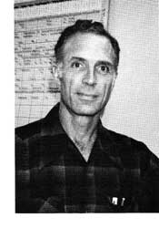 "But Granville was wrong, wasn't he?" says Professor Arthur Sylvester, 43, a geologist and earthquake researcher at the Unversity of California at Santa Barbara. "Granville doesn't understand earthquakes any more than Edgar Cayce or any of the other psychics do. A friend of mine once discovered a one-to-one correlation between cycles of earthquakes and cycles in the stock market. If you believe the psychics, then maybe you should use earthquakes to predict the stock market." "But Granville was wrong, wasn't he?" says Professor Arthur Sylvester, 43, a geologist and earthquake researcher at the Unversity of California at Santa Barbara. "Granville doesn't understand earthquakes any more than Edgar Cayce or any of the other psychics do. A friend of mine once discovered a one-to-one correlation between cycles of earthquakes and cycles in the stock market. If you believe the psychics, then maybe you should use earthquakes to predict the stock market."
Professor Sylvester's methods are not designed to thrill the readers of National Enquirer. He uses laser beams to measure the slow changes in distance between points on the mainland and points on the Channel Islands, and for the last four years he's been in charge of the radon gas sampling program at UCSB.
"Mark Shapiro of Cal Tech isn't predicting any quakes," says Professor Sylvester, "but he's discovered that radon gas in deep wells along the San Andreas fault bubbled up faster just before the 1979 Imperial Valley quake. Then last fall his radon detectors at Lake Hughes and Lytle Creek again showed increases." Also last fall, Professor Sylvester announced significant increases in radon at the detectors along the Mission Ridge, More Ranch, and Mesa faults in Santa Barbara.
The Santa Barbara Channel is one of the most seismically active zones in California: nearly 500 quakes have struck here since 1900. The city itself rides a crustal block bordered by the Mission Ridge fault to the north and the Mesa fault to the south. The Mesa fault extends west from Stearns Wharf to Haley Street, parallels Highway 101 to Modoc Road, then goes under La Cumbre Plaza, where it meets the Mission Ridge fault and continues as the More Ranch fault into the Goleta slough. The Mission Ridge fault passes directly under the Sheffield Reservoir, follows Foothill Road west, then bends behind the Santa Barbara Mission to cross State Street at De La Vina on the way to La Cumbre Plaza.
"Our radon increases turned out to be a false alarm, though," says Dr. Sylvester. "Mark Shapiro's radon samples came from deep wells that seem to be more reliable. We've been using a different method that measures radon gas at the surface. We put a sensitive film strip in holes two feet deep, and once a month we develop the film to count the number of radon 'hits.'
"These surface sampling stations suddenly showed an increase here and all over the state. Then we found out the manufacturer had changed the chemistry of the film. When we recalibrated to adjust to the increased sensitivity of the film, there wasn't any increase at all."
Radon gas as an earthquake precursor was first noticed by Russian chemists who were routinely sampling the hot waters of a spa. They were puzzled by sudden dramatic increases in various gasses--methane, nitrogen, oxides of sulpher, chlorine, fluorine, and radon. While they were pondering this event, a big quake struck 700 miles away. Hindsight showed that there might be a relationship. Radon is the easiest of the gasses to measure, and although there is no real understanding of why these gasses should bubble up faster before a quake, it is generally acknowledged to be a precursor. But precursors don't always mean a quake is on the way; sometimes radon will bubble madly, and no quake will strike.
The crust of the planet Earth is broken into a series of thick, rigid sections, or plates, that are in constant relative motion over the hotter, softer rocks below. The divisions between the plates are called faults, where movement takes place. Global plate tectonics can be likened to a lake frozen over with ice on a winter's day: imagine a mighty rotor beneath the ice churning the water, breaking the ice into separate sections--plates. The jostling might thrust one plate beneath another; elsewhere, water would spurt up to fill gaps, only to freeze and become fresh ice.
The analogy is useful but far from exact because the fastest continental plates move only three inches a year. Where plates are colliding head on, mountain ranges like the Himalayas and the Alps are squeezed up. Where the plates are sliding horizontally past each other, as along the San Andreas fault, the rock of the crust has only a certain amount of elastic strength before it must yield to the strain. We feel the earth shudder when it yields.
"Santa Barbara's faults are not obviously related to the San Andreas fault," says Dr. Sylvester, "and they don't fit well into the plate tectonics scheme, either. The part of California west of the San Andreas fault slips toward the northwest--in 30 million years we'll be a suburb of San Francisco. The San Andreas is called a right-lateral, strike-slip fault, because if you stand on either side of the fault line and look across, the other side has always slipped to the right. Here in Santa Barbara the terrain moves relatively to the left.
 "All our local faults are along the Western Transverse Range. Our mountains and valleys and geological folds in the earth ignore the prevailing northwest and southeast structural grain of California and instead march steadily east and west. Paleomagnetic studies by my colleague Bruce Luyendyk suggest that our Transverse Range once ran north and south, but has rotated 90 degrees clockwise in the last ten million years."
Earthquakes in the Santa Barbara area take place five to fifteen kilometers deep. That's the brittle part of the crust where things snap and break. Beneath fifteen kilometers, heat and pressure make the crust flow like Silly Putty. The transition between brittle and ductile crust depends on how fast the material is moving. Silly Putty lying on a desk will flow smoothly and evenly. If you bend it quickly, it will snap and fracture.
When the ground is ready to fail 15 kilometers down, the surface of the earth may also be warped. It's like breaking a stick: you know that just before the stick breaks it will be at its maximum bend. Geologists measure these surface deformations and other possible earthquake precursors with tiltmeters, creepmeters, strainmeters, magnetometers, seismometers, gravity meters, and other instruments.
All major quakes in southern California for the last 20 years have been preceded by flurries of foreshocks in the general area of the eventual larger quake, A swarm of quakes clustered around the San Jacinto fault near Hemet in February of 1981, but no large quake has followed. Another indication that points to that area as a likely spot for a magnitude 6 or 7 quake is a 30-kilometer stretch of the fault that hasn't slipped since 1899. There's a seismic hole there.
Cal Tech seismologist Karen McNally has detected a pattern of earthquake "bursts," or clusters of quakes, of magnitude 7 or greater in California during the years 1932 to 1934, 1940 to 1942, and 1952 to 1956.
But there's been a 25-year lull. No quakes of magnitude 7 occurred from 1956 until the 1981 quake off the northern coast near Eureka. Magnitude-6 quakes were rare during this time, too. There were two every five years instead of the historical average of two a year.
The lull seems to be over. Thirty-four quakes of magnitude 5 have struck California since August 1978, and five quakes of magnitude 6 since October 1979. We may be merely returning to normal seismic activity-or we may be entering a new burst.
Or it may be just another false alarm. In the summer of 1968, 66 earthquakes struck Santa Barbara, 22 of them large enough to be felt, all under magnitude 5.2. Ten years passed before a larger quake hit-and there is no evidence that the 1968 and 1978 events are related.
Folklore says that animals behave abnormally before earthquakes. One explanation is that animals lying on the ground would be more apt to feel a quake's P wave, the initial pressure wave that arrives before the shock of the main S wave. You might feel the P wave as a slight bump. It travels at the speed of sound in the ground, and is followed by the shake wave that everyone feels. The further away the quake is, the more separated the two waves will be.
Most American seismologists think it is nonsense, but the Chinese believe the animals are detecting something other than P waves, thoogh they can't say what. They put a high value on animal studies in the prediction of earthquakes.
On February 4, 1975, officials of the Manchurian province of Lianong issued an urgent warning: a strong quake would jolt the area within 24 hours. There were many precursors. The ground along the Jinzhou fault had been rising at 20 times the normal rate for a year, and there had been many small quakes. Then snakes began crawling out of the ground, and other animals began acting strangely. At the official warning, the populace went outdoors and stayed out despite the bitter winter weather. At 7:36 that evening a magnitude 7.3 quake struck, demolish-ing 90 percent of the homes in some areas. Because of the warning, only a few people were killed out of a population of three million.
But no animals predicted the Tangshan disaster a year and a half later 400 kilometers to the southeast. There, without warning, a magnitude-8 quake shook the ground for nearly two minutes, turning factories and bridges and railroads into instant junk heaps, while 650,000 sleeping citizens were crushed under the debris of their own homes.
Today Stanford Research Institute has an earthquake hotline for animal studies: a network of 4H youngsters watching their lambs and calves, ranchers observing their horses, zookeepers and pet owners-all watching systematically. Whenever they perceive unusual behavior, they send a postcard to the institute. If there is anything to this animal prediction business, Stanford reasons, there should be an influx of postcards after a shake. But how many people have recorded their dog's actions 24 hours a day, 365 days a year, so that they know bow often the dog decides to prance down the hall sideways?
Not even the Chinese can explain what their animals are reacting~ to that our instruments are not detecting. Perhaps the animals react to changes in the concentration of positive or negative ions in the air, the way Santa Ana winds are supposed to agitate people. Or perhaps the animals are warned by their sense-'of smell when the bubbling gasses carry'traces of various chemicals to the surface.
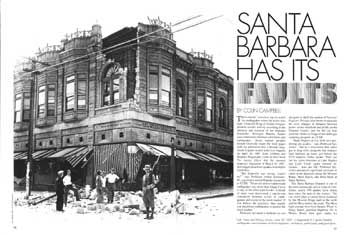
Three hours before the June 29, 1925 Santa Barbara quake, city manager Herbert Nunn woke and could not go back to sleep because of the sudden strong odor of crude oil permeating his home overlooking East Beach. The magnitude 6.3 quake killed 13 Santa Barbarans, ruined the old courthouse, and collapsed the Sheffield Reservoir, sending 45 million gallons of water down Sycamore Canyon through Milpas Street to the ocean. The Mesa fault is the major suspect in that quake, although seismometers never positively identified the epicenter. The greatest intensities were felt along the base of the Mesa, where unconsolidated alluvial fill shook and shifted, and in the Laguna Park area in the southeastern portion of the city, where the high water table contributed to seismically induced liquefaction of the soil.
The big shake of 1925 demonstrated that unreinforced concrete, brick, and masonry buildings were unsuitable, and that buildings of superior design, materials, and workmanship were more likely to survive. One result of the disaster was the stringent Santa Barbara building code.
"The point of the building code is to make sure that the building is tied together throughout so it will overcome inertia and move with the earth as a unit, not as an unrelated assembly of parts," says Professor Sylvester. "Our codes are mostly adequate--but we still don't know everything. The $8-million County Services Administration Building in El Centro was supposed to be earthquake resistant, but it was so badly damaged in the 1979 Imperial Valley quake that it was a total loss.
"Perhaps the most glaring example of poor construction was in the 1964 Caracas quake in Venezuela. Ten-story buildings simply pancaked because the floors and ceilings were inadequately tied together. When everything started shaking, the walls fell outward, and the floors all fell on top of each other.
"Our wooden frame houses in Santa Barbara are pretty safe. I do think, though, that it is prudent to tie down bookcases, and not to have a big potted plant hanging directly over your bed.
"The greatest hazard here in Santa Barbara is to mobile homes. They're up on little stilts--big heavy weights sitting on toothpicks. The ground suddenly moves and the big heavy weight stays behind. We studied a quake at Mammoth Lakes where 300 trailers all stayed up. There they build good sturdy wooden underpinnings because they don't want cold and snow getting under the trailers. Here the trailers have little corrugated metal skirts just for looks."
The largest quake on record for Santa Barbara was the estimated magnitude 7.5 quake of 1812 which is said to have generated seismic sea waves that washed a sailing ship far up Refugio Canyon. It was one of the largest quakes in California history. Another quake of magnitude 7.5 struck in 1927 off Point Arguello, but there was no damage.
The San Andreas fault has not had a major rupture in southern California since the magnitude 8 Fort Tejon quake of 1857. Santa Barbara was strongly shaken, but there was little major damage--cracked adobe here and there. In Ventura the effect was quite severe: the Santa Clara River was thrown completely out of its banks. The San Andreas is. mentioned in The Jupiter Effect, a book by John Gribben and Stephen Plagemann who suggest that the planetary alignment of March 10, 1982, will trigger catastrophic earthquakes along the fault.
"But if you look at that planetary alignment in three dimensions," says Professor Sylvester, "you see that the planets are not in a straight line at all. It just looks that way from Earth. The planets will be within 100 degrees of each other, it's true; but this arrangement happens every 179 years-and the years 1803, 1624, and 1445 were not notably seismic. What generally isn't realized by Jupiter Effect believers is that 99.5 percent of all tidal stresses on March tenth will be imparted by the moon-as usual. Four-tenths of one percent will be imparted by the sun, and Jupiter and all the rest of the planets combined will account for only the last one-tenth of one percent.
"We can forecast that a quake of magnitude 6 may happen here in Santa Barbara at any moment. But that's a forecast, not a prediction. A prediction spells out exactly where a quake will be, when it will happen, and what its magnitude will be. Not one of these questions can be answered with certainty by any method anywhere in the world.
"The probability is that we'll come through any magnitude 6 quake here with minimal damage. We can't predict the big one, the quake of over magnitude 7, but sooner or later there will be another one here--the historical record says so. It won't matter whether you're on a fault line or not-we'll all shake pretty bad.
"Earthquakes are like fog. We have fog here sometimes, and we're likely to have it again. That's a forecast. But we can't predict that next August the fog will roll in at 4:32 on the morning of the fifteenth with a depth of 102 feet and will last ten hours before it rolls out again. Nobody can predict fog that way, and nobody can do it for an earthquake."
|
 |
|